The Ngorongoro Crater is not, geologically speaking, a crater at all, despite the name used for it since colonial times. It is a caldera, a distinct type of volcanic feature formed by collapse rather than by the impact or explosion that the word crater usually implies, and understanding this distinction explains a great deal about why the landscape looks and behaves the way it does today. This guide sets aside questions of fees, itineraries and where to stay, covered elsewhere, to focus specifically on what the crater actually is, how it came to exist, and where it sits within the wider volcanic and geological story of northern Tanzania.
Crater versus caldera, and why the difference matters
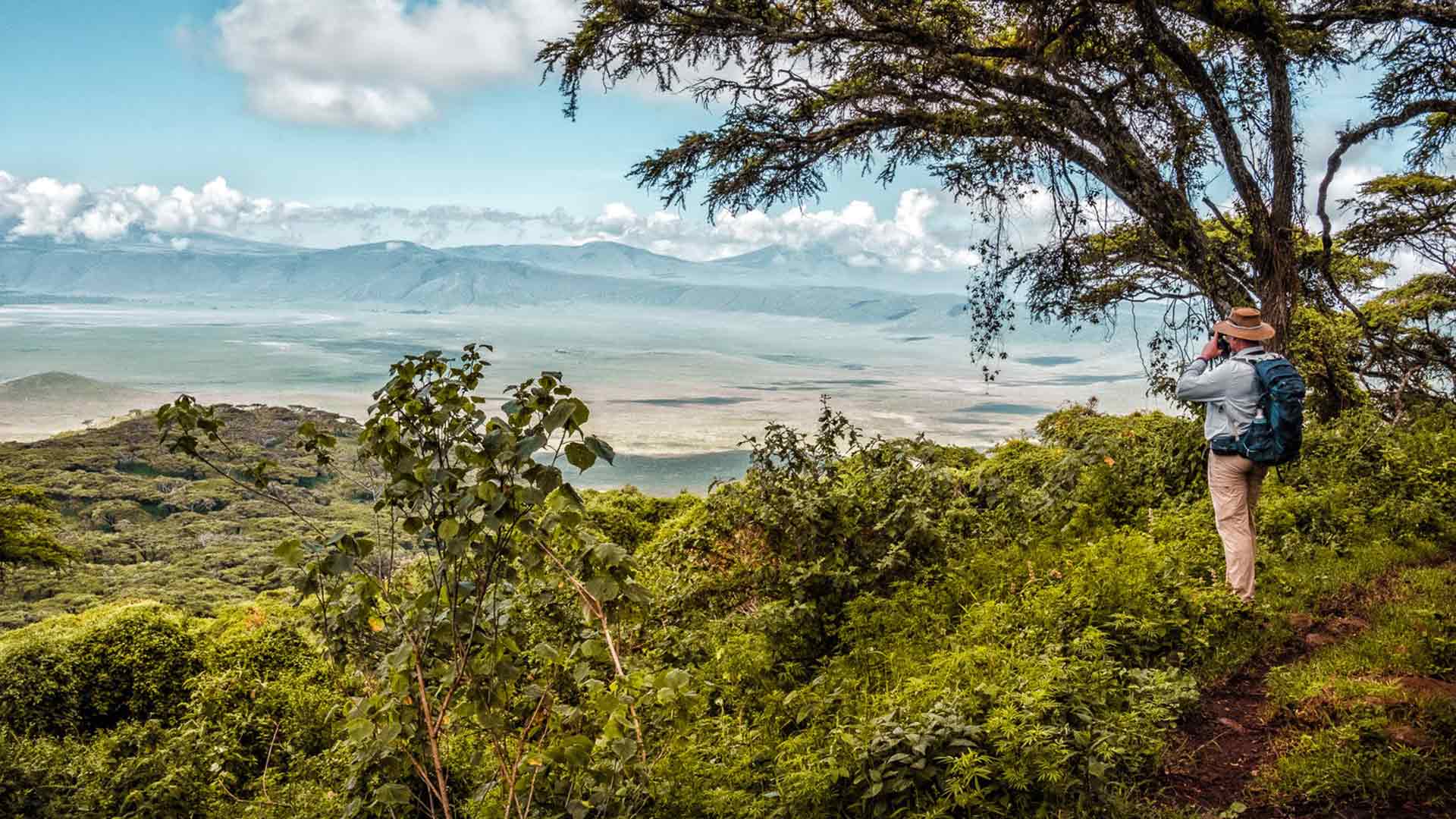
A true crater is a comparatively small, bowl shaped depression formed directly at a volcano’s summit vent by an eruption, or in a different context by a meteorite impact. A caldera is a far larger feature, formed not by an eruption blasting material outward but by the ground collapsing inward after a volcano has emptied a large magma chamber beneath it, leaving the surface unsupported and prone to sinking into the void left behind. Ngorongoro is one of the world’s largest examples of this second, collapse driven process, and the distinction is why the depression is so much wider and gentler in profile than a typical volcanic crater, with sloped, vegetated walls rather than a steep, jagged rim.

How the caldera formed
Around 2.5 million years ago, a large stratovolcano stood where the crater now sits, part of a chain of volcanic centres along the Gregory Rift, the eastern branch of the wider East African Rift Valley system. Geologists estimate this original volcano may have reached an elevation somewhere between 4,500 and 5,800 metres before its collapse, tall enough to have rivalled or even exceeded the height of nearby Kilimanjaro at the time. Following a major eruption that emptied much of the volcano’s underlying magma chamber, the unsupported summit collapsed inward on itself, rather than being blown apart, leaving behind the vast, largely intact bowl visible today. Because the collapse happened as a single implosion rather than through a slower process of gradual erosion, the caldera’s floor and walls have remained remarkably whole, without the deep breaches or partial rim loss seen at many other calderas around the world.
Where Ngorongoro sits within the wider volcanic landscape
Ngorongoro is one of several volcanic features that together make up the Ngorongoro Volcanic Highlands, a cluster of coalescing shield volcanoes sitting at the centre of the divergence zone where the Gregory Rift meets the older Eyasi Rift structure to the south. Two smaller calderas, Olmoti and Empakaai, sit to the north of the main crater and were formed by broadly similar volcanic processes, though both are considerably smaller and shallower, and neither supports anything close to the density of resident wildlife found on Ngorongoro’s floor. This wider volcanic complex is itself part of the East African Rift Valley, the vast geological system running from the Red Sea down through Kenya and Tanzania, along which magma rising from below the earth’s crust has produced most of the region’s dramatic peaks, including Kilimanjaro and Mount Kenya.
How the collapse differs from a simple sinkhole
It is worth being precise about what collapsed and why, since the word collapse can suggest something closer to a sudden sinkhole opening beneath a road, which is not an accurate picture of what happened at Ngorongoro. In the period leading up to the collapse, the original volcano would have erupted repeatedly over a long span of time, each eruption emptying some portion of the magma chamber sitting beneath the mountain. Once enough magma had been expelled, the rock above the emptied chamber lost the physical support that had been holding it up, not unlike a floor with its supporting beams progressively removed. The summit then subsided under its own weight in a process that likely unfolded over a period of days to years rather than in a single instant, fracturing along ring shaped faults around the edge of the depleted chamber and sinking as a broadly coherent block rather than crumbling apart entirely, which is precisely why the resulting caldera floor and walls remain so structurally whole today.
The name itself
The most widely accepted origin of the name Ngorongoro traces to the Maasai term for the sound made by cowbells, a reference to the cattle bells once carried by Maasai herders grazing livestock in and around the crater floor before wildlife conservation restrictions tightened over the twentieth century. A separate but related account attributes the name to a Maasai phrase translating roughly to big hole or big bowl, a straightforwardly descriptive reference to the caldera’s shape as seen from the surrounding highlands. Both explanations point to the same underlying reality, a landscape whose local name long predates any formal geological description of how it actually formed.
What the floor and rim are made of today
The crater’s floor is predominantly open, short grass plains, interspersed with a scattering of acacia woodland, a network of seasonal and permanent watercourses, and Lake Magadi, a shallow soda lake fed by the Munge River near the floor’s centre. Soda lakes of this kind form where volcanic activity has left the underlying groundwater rich in dissolved minerals, producing the alkaline conditions that support the algae attracting the crater’s resident flamingo population. The surrounding rim, by contrast, is heavily forested with montane vegetation, a markedly different habitat from the open floor below and one that receives noticeably higher rainfall given its greater elevation, a pattern typical of East Africa’s highland forest zones.
Why the ecosystem functions as a near closed system
Unlike the wider Serengeti ecosystem, where the annual wildebeest migration moves enormous numbers of animals across huge distances following seasonal rainfall, most of the large mammal population living on the Ngorongoro Crater floor is effectively resident rather than migratory. The crater’s steep walls and relatively narrow access routes create a natural degree of enclosure, though it is important to note the system is not completely sealed, since some animals, most notably wildebeest and zebra, do move in and out via specific access points depending on seasonal grazing conditions. This near closed structure, combined with permanent water sources on the floor even during the driest months, is a large part of why wildlife density inside the crater remains consistently high across the entire year rather than fluctuating with a migratory pattern the way the wider ecosystem does.
How Ngorongoro compares with other famous calderas
Crater Lake in Oregon, formed by the collapse of Mount Mazama around 7,700 years ago, offers a useful point of comparison precisely because it illustrates the alternative outcome after a caldera forms. Rather than remaining dry like Ngorongoro, Crater Lake’s basin filled with rainwater and snowmelt over centuries to form the deep, clear lake now visible, since its climate and drainage pattern differ substantially from the seasonally dry East African rift environment. Yellowstone’s caldera, though vastly larger in total area, sits beneath an active geothermal system still capable of future eruption, a meaningfully different situation from Ngorongoro’s dormant, long stable volcanic history. These comparisons help explain why Ngorongoro’s specific combination, large, unbroken, dry and volcanically inactive, is genuinely unusual rather than simply another example of a common landform.

How geologists study and date the caldera
Much of what is known about Ngorongoro’s formation comes from radiometric dating of volcanic rock samples taken from the crater’s walls and surrounding highlands, a technique that measures the decay of naturally occurring radioactive isotopes within volcanic minerals to estimate when the rock originally cooled and solidified. This dating work places the collapse at approximately 2.5 million years ago, broadly consistent with dating from the nearby Olduvai Gorge, one of the most significant paleoanthropological sites in the world, where layered volcanic ash deposits have allowed researchers to date early hominin fossils and stone tools with unusual precision. The proximity of Olduvai to Ngorongoro is not coincidental, since the same volcanic activity that built and later collapsed the crater also blanketed the surrounding landscape in the ash layers that later preserved evidence of early human ancestors for scientists to uncover millions of years afterward.
The rift valley context that produced it
Ngorongoro’s formation cannot be fully separated from the broader story of the East African Rift, the vast tectonic system along which the African continent is slowly splitting apart as two tectonic plates pull away from each other at a rate of only a few millimetres per year. This gradual stretching thins the earth’s crust, allowing magma to rise closer to the surface and periodically erupt through volcanic vents across a corridor running from the Red Sea, through Ethiopia, Kenya and Tanzania, and into Malawi and Mozambique further south. Ngorongoro, Kilimanjaro, Mount Kenya and Mount Meru are all products of this same underlying tectonic process, though each has followed a distinct individual history of eruption, growth and, in Ngorongoro’s case, eventual collapse.
Its place among the world’s calderas
Among the world’s volcanic calderas, several are considerably larger by raw surface area, but Ngorongoro’s specific distinction is being the largest unbroken and unflooded caldera on earth, meaning its rim has neither been breached by later erosion or a further eruption, nor has its floor filled with water to form a crater lake, as has happened at many comparably sized calderas elsewhere. This intact quality is precisely what makes the site both a significant subject for volcanological research and, more immediately relevant to visitors, what has preserved the enclosed floor as a single continuous wildlife habitat rather than a landscape fragmented by later geological disturbance.
Why the geology still matters to a modern visitor
None of this history is simply academic background for anyone actually planning to visit. The caldera’s collapsed, bowl shaped structure is precisely why wildlife concentrates so reliably on the crater floor rather than dispersing across a wider territory, and it is why the descent by vehicle from the forested rim down onto the open grassland below feels like entering a genuinely different world within a matter of minutes rather than a gradual transition. Understanding that the crater is a single geological event frozen in place, rather than an ordinary valley or basin shaped by ordinary erosion over a much longer period, helps explain why the site is described so consistently, by geologists and safari guides alike, as one of the most distinctive landscapes anywhere on the African continent. A visitor standing on the rim at first light, looking down at a floor that took a single geological event to create rather than millions of years of gradual carving, is looking at something genuinely rare among the world’s great wildlife landscapes, and that rarity is a direct product of the specific, collapse driven process described above rather than an accident of naming or marketing.